
Sapporo is ringed by mountains, and that is the problem: on a two- or three-day trip you can realistically fit one hike, not five. The five below are all close enough to the city that the choice comes down to time, fitness and what you want to see at the top.
The short version: if you have half a morning, choose Mt. Maruyama. If you want a proper climb and the best city view, choose Mt. Moiwa. Mt. Sankaku is the other genuinely beginner-friendly option, Mt. Hakkenzan is short but exposed and belongs to hikers with some experience, and Mt. Teine is a half-day to full-day outing rather than a morning stroll. All of that assumes open trails and reasonable weather — winter conditions and bear safety are covered further down.
Last checked: November 2026. Trail conditions, fares and closures change from season to season, so confirm the details before you set out.
Short on time but unsure which Sapporo trail suits your group? A private guided morning hike lets you explore routes matched to your fitness level without planning every turn yourself.
Check available dates, start times, and trail choices for the Sapporo guided morning hike.
Which Hike Near Sapporo Is Best for You?
Most visitors are choosing between the three low mountains inside the city — Maruyama, Moiwa and Sankaku — because they are the only ones reachable by subway and bus without losing half a day to transport. Hakkenzan and Teine are better hikes in the abstract, but they need a car and a longer window.
Use the table below to narrow it to one. The details for each mountain follow.
| Hike | Best for | Summit elevation | Approx. ascent time | Access | Difficulty | Main drawback |
|---|---|---|---|---|---|---|
| Mt. Maruyama | A short morning out; forest rather than big views | 225 m | About 40 min | Subway to Maruyama-Koen, then a 10-min walk | Easy to moderate | Root-covered and busy; not a flat walk |
| Mt. Moiwa | A half-day climb with the best city view | 531 m | About 75 min | Subway, then bus to Jikeikai-mae, 2-min walk | Moderate | Long climb; sunset crowds and a long descent |
| Mt. Sankaku | Beginners who want a summit view without a long climb | 311 m | About 45 min | Subway, then bus, then a 5-min walk | Easy to moderate | Bus transfer; less dramatic forest |
| Mt. Hakkenzan | Experienced hikers who want exposure and rock | 498 m | About 60 min | Car, about 35 min from the city center | Hard | Cliffs and fixed ropes; not for anyone uneasy with heights |
| Mt. Teine | A long day out with no crowds | 1,023 m | 3 hrs or more, route dependent | Car or bus, depending on the route | Moderate to hard | Route-finding and time; a ski area in winter |
Ascent times above are one-way from the trailhead. They exclude the walk from the station, rest stops and the descent — which is why a “40-minute hike” can still take three hours out of your day. Teine’s time varies so much between routes that any single figure would mislead.
If the route choice itself is what worries you, a guided morning hike is the other way to do this: someone else picks a trail to match your fitness and the day’s weather, and meets you at Maruyama-Koen Station.
Mt. Maruyama: The Easiest Hike to Fit Into a Sapporo Day
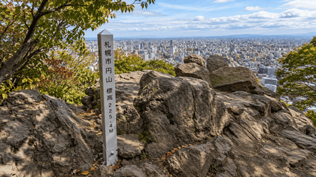
Mt. Maruyama is 225 m high, sits at the edge of the city, and takes about 40 minutes to climb from the Hachijuhakkasho trailhead. That combination — short, close, genuinely forested — is why it is the hike I suggest first to visitors with a spare morning.
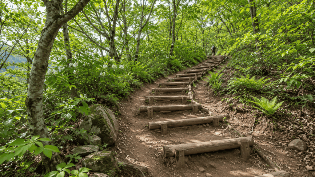
The mountain is protected as a national natural monument, designated in 1921, and the primeval forest covering it is the real reason to come. The Hachijuhakkasho route begins among lines of small Buddhist statues dressed in knitted hats and bibs by local residents, then climbs into tall, dense trees. This is not a park path. From the first few minutes the trail tilts upward, and much of it runs over exposed tree roots that stay slick after rain.
That gap — modest elevation, unmodest footing — is the single most misread thing about Maruyama. A 225 m mountain sounds like a walk; parts of this one are a climb. In dry summer conditions, firm trainers are enough. After heavy rain, once the roots are wet and muddy, they are not, and the descent is where most people notice.
To start, leave Maruyama-Koen Station on the Tozai Line and walk about 10 minutes south along Minami Ichijo-dori toward Maruyama Zoo. The route is easy to follow; the last stretch climbs a residential slope, which surprises people who budgeted exactly ten minutes and no more.
At the top the trees open onto a rocky viewpoint with the city below — a good place for the lunch you brought, and a short stop rather than a destination in itself. Red squirrels and woodland birds do turn up in the forest, but treat a sighting as luck rather than a plan.
Best for: a two-hour window, a first taste of Hokkaido forest, travellers who would rather walk among trees than chase a panorama. Skip it if: you want a flat, paved stroll, you are pushing a stroller, or root-covered descents are hard on your knees. Maruyama Park at the base is the gentler alternative. Expect company, too — this is a local exercise route as much as a visitor trail.
Mt. Moiwa: The Best Longer Hike for City Views
Mt. Moiwa is 531 m, and the view from the top is the one you have seen in every Sapporo photograph: the city grid, the Toyohira River, and on a clear day the Sea of Japan. The most popular walking route starts at the Jikeikai Hospital trailhead, covers about 2.9 km and takes roughly 75 minutes one way.
Five trails climb the mountain. The Jikeikai route is the busiest and best maintained, with toilets, drinking water and a washing area at the entrance. Kita-no-sawa is the shortest at about 2.4 km, the Asahiyama Memorial Park route is around 4.0 km and more undulating, and Kobayashi Pass is the longest at roughly 4.5 km. Without a car, Jikeikai is the sensible default.
The climb is a steady, broad forest path rather than a scramble, passing through protected primeval forest with large linden trees. It is longer than Maruyama but technically simpler — fewer roots, fewer surprises underfoot — which suits travellers who want a real half-day of walking more than those who want the shortest possible outing.
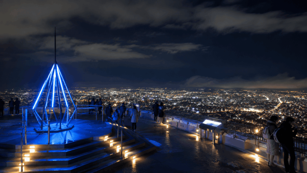
The facilities at the top are the other half of the appeal: toilets and changing rooms on the first floor of the ropeway summit station, a restaurant, and an observation deck. That means you can climb in hiking clothes, change, eat, and ride down without carrying the city version of your wardrobe with you.
Best for: a half-day, a proper climb with a payoff, anyone willing to earn the classic Sapporo view. Skip it if: you have three hours or less, you are hiking with young children new to uphill walking, or you plan to be on the summit at dusk and walk down afterwards. The descent is the part people underestimate.
Is Mt. Moiwa Better at Sunset or During the Day?
Sunset is why many people come, and it is also why the summit gets uncomfortable. On weekend evenings the deck fills with ropeway passengers who arrived in the final hour before dark, and the wind is strong enough that a warm summer afternoon turns cold within minutes of the sun dropping.
The timing depends entirely on the month. In early November the sun is gone by about 16:30; in early December it sets before 16:00; in late June it is still light at 19:00. A fixed “go at sunset” plan is meaningless without checking the date.
| What changes at sunset | What it means for you |
|---|---|
| Crowds | The deck is busiest in the 60–90 minutes before dark, mostly with ropeway visitors |
| Temperature | Wind chill arrives fast; carry a shell even in July and August |
| Descent | If you walked up, you need daylight for the way down — the forest darkens well before the sky |
| Ropeway | Weather can suspend service; the last upward departure is around 21:30, so check the last descent time for your date |
The practical rule: if you are walking both ways, start down at least an hour before sunset, which in November means heading down by mid-afternoon. If the night view is the point, ride up and ride down, and accept the crowd as part of the experience. What I would not do is recommend a dark forest descent as a way to dodge the queue — the path is broad and well marked, but roots, wet leaves and tired legs are a poor combination in failing light.
Hiking Mt. Moiwa vs. Taking the Ropeway
These are two different activities that happen to end in the same place. Walking up is about 75 minutes of forest; the ropeway is a five-minute cable car plus a short mini cable car ride, and delivers you to the same deck.
Fares for the ropeway and mini cable car together are around ¥2,100 return for adults, or about ¥1,050 one way, with children’s tickets at half price. In summer the service runs from 10:30 to 22:00 and in winter from 11:00 to 22:00, roughly every 15 minutes, with the last upward departure at 21:30. It is scheduled to close for annual maintenance from 29 March to 28 April 2027, and it stops in high winds or poor visibility. Fares and hours are exactly the kind of detail that changes, so check the operator’s page for your dates.
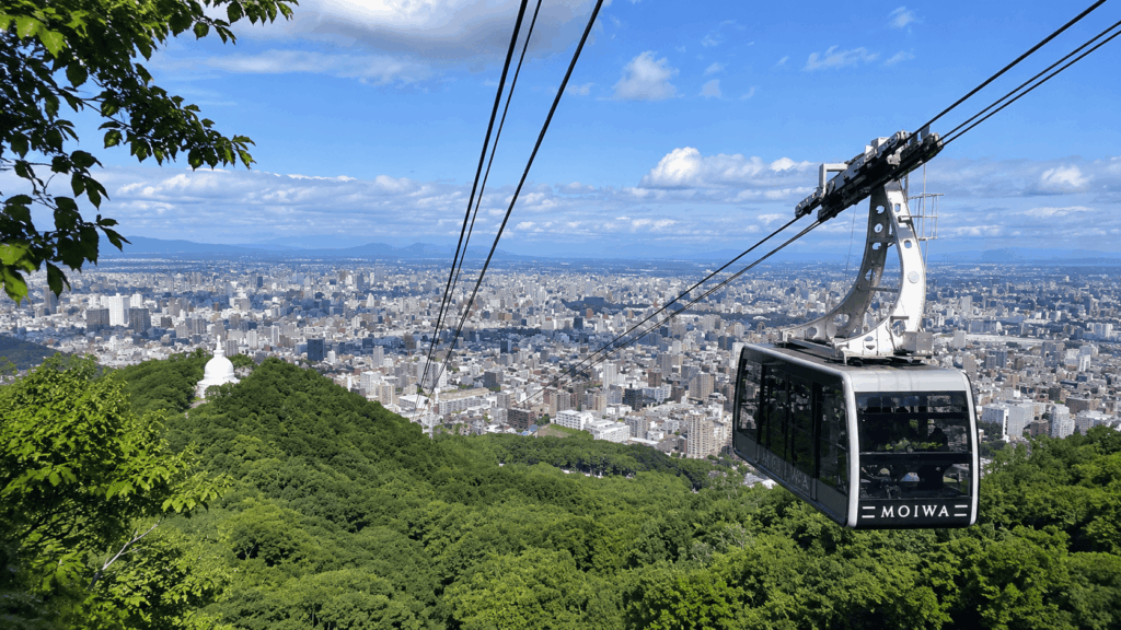
The combination most people enjoy is walking up in the afternoon and riding down after the view — forest and panorama, finishing before the cold settles in. The catch is that this only works if the ropeway is running when you want it. If the weather is marginal, decide before you start climbing, not at the top. Choose the ropeway both ways if the view matters more than the walk, or if someone in your group cannot manage 75 minutes uphill; choose the hike if the forest is the point, because you will see almost none of it from the cable car.
If you would rather enjoy Mt. Moiwa’s summit view without hiking, compare the current round-trip ropeway and mini cable car ticket on Klook. This covers riding both ways, not a one-way descent after hiking, and the operating status should be checked separately.
Mt. Sankaku: Another Good Beginner Option
Mt. Sankaku is 311 m, takes about 45 minutes one way from the Yamanote trailhead, and has the best footing of the three city mountains. If Maruyama’s root-covered slopes sound unappealing but you still want a short climb with a view, start here.
Three trailheads serve the mountain — Yamanote, Kobetsuzawa and Miyanomori — and Yamanote is the most convenient without a car. It has toilets, the path from there is broad and well signed, and the grade is gentle enough for children and visitors who have not hiked in years. The summit holds a first-class triangulation station and opens onto the whole city, a sharper panorama than Maruyama offers.
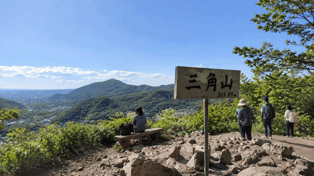
Access takes one more step: from Nishi 28-chome Station on the Tozai Line, take a JR Hokkaido bus on the Yamanote loop (routes 20 and 21) to Yamanote 4-jo 11-chome. The ride takes 8 to 17 minutes depending on the route, and the trailhead is a five-minute walk from the stop.
Best for: beginners who want a summit view, families with children old enough to walk for an hour, anyone staying near Maruyama who wants a second short hike. Skip it if: you want the simplest possible journey — the bus transfer and the wait for a return service make this a longer day than Maruyama for a similar amount of walking.
One honest limitation: I have not climbed Sankaku myself, so this section draws on the city’s trail information and on consistent reports from other hikers rather than my own feet. The footing is described as good in dry conditions; after rain or snow, treat any low mountain here as a different proposition.
Maruyama, Moiwa and Sankaku Side by Side
| Factor | Mt. Maruyama | Mt. Moiwa | Mt. Sankaku |
|---|---|---|---|
| Hiking experience | Short forest climb with a rocky viewpoint | Longer, steadier forest walk to a full panorama | Short climb to a wide summit view |
| Trail surface | Root-covered, steep in sections, slippery when wet | Broad and well maintained; fewer roots | Good footing; gentler grade |
| View | Partial, through trees, from a rock outcrop | The classic panorama, plus night views | Open view over the whole city |
| Time commitment | About 2 hours door to door | About 4 hours door to door on foot | About 3 hours door to door |
| Public transport | Subway plus a 10-minute walk | Subway, bus, 2-minute walk | Subway, bus, 5-minute walk |
| First-time hikers | Yes, with footwear that grips | Yes, if you have the time and daylight | Yes, the most forgiving underfoot |
| Best time of day | Morning | Afternoon into early evening | Morning or early afternoon |
Mt. Hakkenzan and Mt. Teine: For More Experienced Hikers
These two are why a “best hikes near Sapporo” list can mislead. Neither is a city stroll, and neither should be slotted into a free morning on the strength of its elevation alone.
Mt. Hakkenzan: Short but Exposed
At 498 m, Hakkenzan is lower than Moiwa and takes roughly an hour to climb from the Minamiguchi trailhead. It is also the most demanding walk in this guide. The upper section follows fixed ropes over steep rock, with drops close to the path and a summit approach that needs hands as well as feet; the city’s own guidance warns that anyone uneasy with heights should think twice.
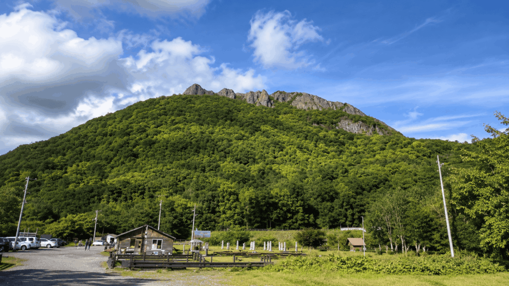
Hikers register at the mountain lodge before setting out — worth taking seriously on a mountain where the route is not simply a wide forest path. The reward is a view over the Toyohira River valley and the cliffs below, and autumn is the season most often recommended. Access is the other obstacle: about 35 minutes from central Sapporo by car, or an hour or more by bus plus a walk, which turns a one-hour climb into most of a day.
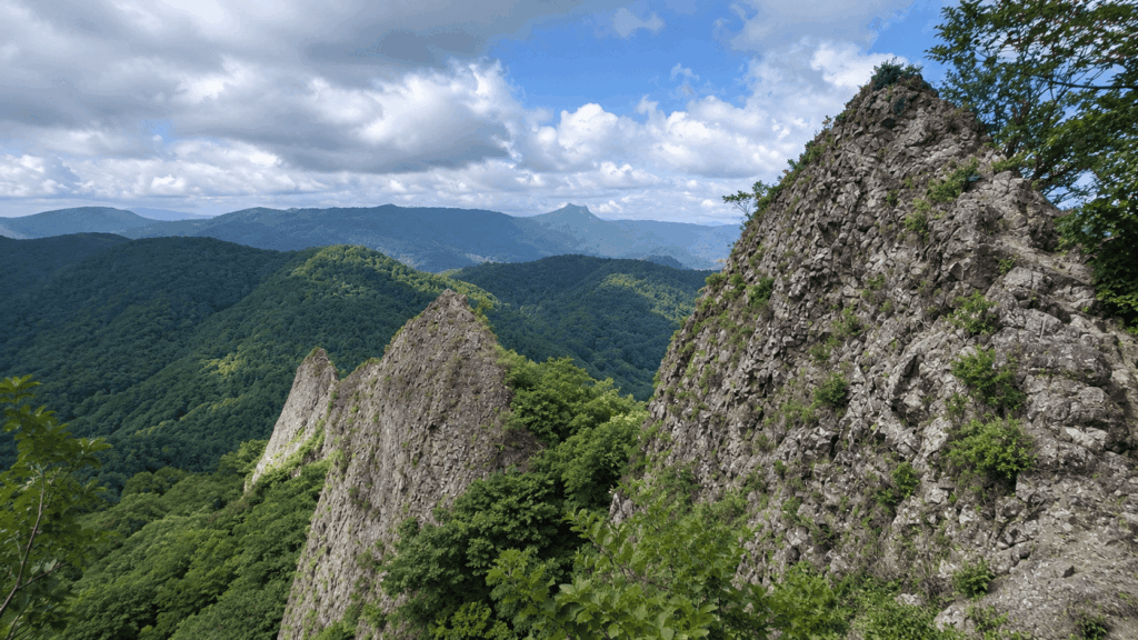
Best for: hikers with scrambling experience and a rental car. Skip it if: you are hiking with children, you dislike heights, or you only have half a day. A low summit is not a low-risk summit.
Mt. Teine: A Half-Day or Full-Day Outing
Mt. Teine reaches 1,023 m, and the routes differ enough that no single time estimate is honest — published figures run from around three hours to the summit on shorter approaches to five hours or more for a return trip. What is consistent is that this is a mountain for people who already hike, who can read a route description, and who have a car or a clear transport plan. In winter the same mountain operates as Sapporo Teine ski area, and summer trail information does not transfer.
Best for: experienced hikers with a full day and their own transport. Skip it if: you are fitting a hike around other plans, or you want a guaranteed summit in a fixed number of hours.
How to Reach Sapporo’s Trailheads Without a Car
The three city mountains are genuinely car-free options, not “car-free with a taxi at the end”. The last leg is where most of the friction sits. (If your Japan itinerary also includes the capital, see our comparison of easy hikes near Tokyo by train for similar transit-friendly trails.)
- Mt. Maruyama: Tozai Line to Maruyama-Koen Station, then about 10 minutes on foot along Minami Ichijo-dori toward Maruyama Zoo.
- Mt. Moiwa: Tozai Line to Maruyama-Koen Station, then a JR Hokkaido bus on loop route 10 or 11 to Jikeikai-mae, then two minutes on foot to the Jikeikai Hospital trailhead.
- Mt. Sankaku: Tozai Line to Nishi 28-chome Station, then a JR Hokkaido bus on the Yamanote loop to Yamanote 4-jo 11-chome, then five minutes on foot.
- Mt. Hakkenzan and Mt. Teine: realistically car-dependent. Buses exist for both but add an hour or more each way and rarely line up neatly with a hike.
Bus frequencies thin out outside peak hours, and the return trip is the part people forget to plan. Before you start walking, note the last practical bus back and work backwards — not the other way round.
Kai’s tip: The 40-minute figure for Maruyama is measured from the trailhead, and the ten-minute walk from Maruyama-Koen Station finishes with an uphill pull along a residential street. I have watched visitors plan a “quick hike” around those two numbers and end up rushing the part of the morning that was worth slowing down for. Add twenty minutes on each side and the day stops feeling like a schedule.
When Is the Best Time to Hike Near Sapporo?
Snow-free months are the simple answer, but the edges of the season are where trips go wrong. Spring arrives late here, and the first snow comes earlier than visitors from milder climates expect.
- Spring: trails open from late April, but snow patches and mud persist on shaded sections into May. Expect wet ground rather than dry paths.
- Summer: the most reliable window. Long daylight, warm days, cool evenings; busy at weekends, rarely crowded on weekday mornings.
- Autumn: the best colours and sharpest air, with one catch — sunset moves fast. By mid-October it is dark before 17:00, so an afternoon start needs a tighter plan than the same walk in August.
- Winter: possible on the city mountains, but a different activity with different equipment. See below.
Kai’s tip: On weekend evenings the Moiwa summit is at its busiest exactly when the light is at its best, and the wind up there makes it feel several degrees colder than the streets below. When I am helping someone plan that evening, I suggest arriving earlier than the sunset time implies and carrying one more layer than the forecast suggests. The difference between a memorable hour and a shivering one is usually a shell jacket, not timing.
Can You Hike in Sapporo in Winter?
Yes, and locals do it constantly. But “popular in winter” is not the same as “safe for a visitor in the wrong shoes”, and that distinction is the whole conversation. The city mountains in winter are packed snow and, after a thaw and refreeze, polished ice. Descents are harder than climbs, because gravity is doing the work and your edges are not.
- Waterproof winter boots with a real tread — not fashion boots, not trainers
- Traction devices that fit over the boot, such as microspikes, for packed or icy sections
- Trekking poles, which do more for confidence on a descent than most people expect
- Insulating layers plus a windproof shell; the summit will be colder than the trailhead
- A headlamp, because daylight is short and plans slip
- A current forecast and a look at trail conditions before leaving the hotel
If any of those are missing, or the forecast is marginal, the honest answer is to walk in Maruyama Park or ride the Moiwa ropeway instead. A winter view is not worth a torn ankle on a slope you cannot see under the snow.
Kai’s tip: Winter boots keep your feet warm and dry; they do not necessarily keep you upright. On the packed, polished sections of Maruyama and Moiwa, the difference between a comfortable descent and a tense, slow one is usually a pair of traction devices rather than a better boot. I have had this conversation with visitors who arrived in excellent snow boots and still could not stand on a slope.
Bears, Trail Closures and Sunset: What to Check Before You Go
Sapporo’s mountains are bear habitat, and the city publishes sightings as they are reported. In October 2026 a bear was recorded on the Moiwa route of the city’s nature trails, roughly 600 metres from the Jikeikai Hospital entrance. That is a single record, not a closure notice — but it is exactly the kind of information that should change your plan for the day.
Two things are easy to confuse, so keep them separate. The Moiwa scenic drive and the nature study path alongside it close for the season on 20 November 2026; that is a seasonal road closure, not a shutdown of the five hiking courses. Equally, a sighting on one route does not mean every trail is closed — but it does mean you should not assume a trail is open just because it appears on a map.
Before you leave, check the city’s bear sighting page, the city’s nature trail information, the ropeway’s operating status if you plan to use it, the forecast, and the sunset time for your date. Then decide. If you cannot confirm trail status, choose a different walk.
Should You Hike Independently or Book a Guided Tour?
For a confident walker on a clear day, the city mountains do not require a guide. The trails are marked, the access is described above, and Maruyama in particular is hard to get lost on. Paying someone to walk beside you is not a safety upgrade you automatically need.
The calculation changes when the obstacles are not the trail itself. If this is your first mountain hike abroad, if you are travelling with children or a partner whose fitness differs from yours, if you want to ask questions in English as you go, or if choosing between five Moiwa routes sounds like homework, a guide removes the part of the day that eats into your holiday.
| Factor | Self-guided | Guided |
|---|---|---|
| Cost | Free trailheads; you pay only for transport | A per-person tour fee; check the current price |
| Flexibility | Start when you like, change plans mid-walk | Fixed start time; route adjusted within the tour |
| Navigation | You follow the signs; junctions on Moiwa need attention | The guide handles the route |
| Local information | What you read beforehand | Context and answers in English as you walk |
| Fitness matching | You judge your own pace | The route is chosen for your group |
| Safety planning | Your call on weather, bears and daylight | The guide monitors conditions — but does not remove the risk |
| Who should choose it | Confident walkers with time to spare | First-time mountain hikers, mixed-fitness groups, anyone uneasy about route-finding |
If that second column describes you, the relevant option is a private morning hike sold through GetYourGuide and operated by HBT LLC. It runs two to three hours, is booked as a private group, and is offered in English, Japanese and Chinese — the English is listed as conversational rather than native, which is worth knowing if you have detailed questions. You choose from Mt. Maruyama, Mt. Moiwa, Mt. Sankaku, Mt. Teine or Mt. Okura when booking, and the route is matched to your fitness. The meeting point is around Maruyama-Koen Station, with the Starbucks in the Maruyama Class building named as the start; confirm the exact spot when you book.
The listing offers free cancellation up to 24 hours ahead, mentions a light snack and water, and asks you to bring hiking clothing, footwear and your own water, so read the inclusions carefully. It is not suitable for children under three, pregnant travellers, people with heart conditions, wheelchair users or visually impaired travellers. And a guide does not cancel out a bear sighting or a bad forecast: you are still hiking in the same mountains, with the same weather, under the same rules.
For travelers who want a Sapporo mountain hike but would rather have help choosing the route and adjusting the pace, this private morning option is the closest match to the needs described above.
Why I’d book this one
- Recent traveler reviews mention flexible planning around group needs and weather conditions.
- Travelers also highlight local stories, helpful guidance, and useful tips for the rest of their Sapporo visit.
- The listing offers private-group booking and flexible reservation terms; check the conditions for your chosen date.
See current availability, start times, and recent traveler reviews for Sapporo: Guided Morning Hike.
Frequently Asked Questions
What is the easiest mountain to hike in Sapporo?
Mt. Maruyama, on the strength of access and total time rather than the trail itself: 225 m, about 40 minutes from the Hachijuhakkasho trailhead, and a 10-minute walk from Maruyama-Koen Station. Be clear about what “easiest” means — the path is short, not flat. Roots and short steep sections make the descent more demanding than the elevation suggests, and wet or icy conditions change the difficulty entirely. For the most forgiving surface underfoot, Mt. Sankaku is the better choice.
Can you hike near Sapporo without a car?
Yes, for the three city mountains. Maruyama is subway plus a 10-minute walk; Moiwa is subway, bus to Jikeikai-mae, then a 2-minute walk; Sankaku is subway, bus to Yamanote 4-jo 11-chome, then a 5-minute walk. Hakkenzan and Teine are practical only with a car or a long bus day. Check the return bus times before you start walking — services are infrequent outside peak hours.
How long does it take to hike Mt. Moiwa?
The Jikeikai Hospital route is about 2.9 km and roughly 75 minutes one way to the summit, according to the operator. That is the ascent only. Add the descent, rest stops and the trip from your hotel, and a walked round trip is closer to four hours. If you ride the ropeway down, the walk becomes a half-day rather than most of a day.
Is hiking in Sapporo safe in winter?
It can be, with the right equipment and experience — and it is not, with ordinary winter boots and a free afternoon. The city mountains are packed snow and ice in winter, and descents are where people fall. Waterproof boots with real tread, traction devices such as microspikes, poles and a headlamp are the baseline, not the upgrade. If you cannot confirm conditions, or you have no experience walking on snow, use the Moiwa ropeway or walk in Maruyama Park instead.
Are there bears on hiking trails near Sapporo?
Yes. The mountains around the city are bear habitat, and sightings are reported through the season — including a record on the Moiwa route in October 2026, about 600 metres from the Jikeikai Hospital entrance. A sighting is not the same as a closure, and it does not mean every trail is off limits, but you should check the city’s live sighting page and trail information on the morning you plan to walk, and change plans if a route has recent reports.
Final Verdict: Which Sapporo Hike Fits Your Trip?
There is no single best hike here, only a best fit for the time and conditions you actually have.
If this is your first visit to Sapporo
Hike Mt. Maruyama in the morning and keep the rest of the day for the city. One subway line, a short walk, about 40 minutes up, and a forest that feels nothing like a city park. Wear shoes with grip, start before mid-morning, and treat the summit as a snack stop rather than a destination.
If you want the view more than the walk
Take the Mt. Moiwa ropeway up in the late afternoon, watch the city change colour, and ride down. With legs and daylight to spare, walk up and ride down instead — forest and panorama in one afternoon. Do not plan a walked descent after dark on your first visit.
If you are travelling with family or mixed fitness
Choose Mt. Sankaku. The Yamanote trailhead has toilets, the footing is the best of the three city mountains, and the summit arrives after about 45 minutes. Maruyama works too, but its root-covered descent is harder for children and older knees than the height implies. If fitness varies widely, a private guided morning hike lets the route be chosen around the slowest person rather than the average.
If you have half a day or less
Skip Moiwa on foot and skip Hakkenzan entirely. Maruyama fits comfortably into a morning; Sankaku fits if you are staying on the west side of the city. Anything involving bus transfers both ways plus an hour of climbing will eat the half-day you were protecting.
If you hike regularly and want more than a city viewpoint
Mt. Hakkenzan is the short, sharp option — an hour of climbing with fixed ropes, rock and real exposure, and a car needed to reach it. Mt. Teine is the long option, with routes that take most of a day. Neither is a substitute for a morning walk, and neither rewards a casual start.
If you are visiting in winter
Decide on equipment, not ambition. With waterproof boots, traction devices and daylight, Maruyama is a beautiful short walk and Moiwa’s forest is quieter than in summer. Without them, ride the Moiwa ropeway for the night view and walk the flat paths of Maruyama Park at the base. The mountain will still be there next trip.
Whichever you choose, the pattern is the same: match the mountain to your available hours, add time for the walk from the station, check trail and bear information on the day, and start down earlier than feels necessary. The hikes near Sapporo are close enough that the constraint is almost never distance — it is daylight, footing, and the bus you meant to catch.
Hi, I’m Kai. I’m a Tokyo-based travel writer, tourism industry insider, and the author of a published guidebook for international visitors to Japan. With over 10 years of professional experience at a leading Japanese tourism company, my mission is to help you skip the tourist traps and navigate Japan’s best destinations like a local. I believe the perfect day trip is like a traditional kaiseki meal: a beautiful balance of precise planning and unforgettable seasonal discovery. When I’m not out conducting field research, you’ll usually find me drafting new itineraries with one of my favorite fountain pens!